Over Canvas Prints
Aangeboden door
Over dit ontwerp
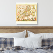
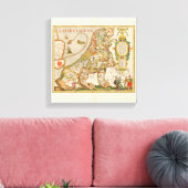
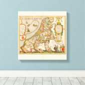
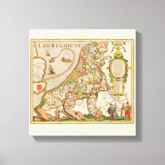
Great Old Map of Belgium (Year 1617) Canvas Afdruk
Nice old color example of the Leo Belgicus map of the 17 United Provinces, one of the most dramatic decorative works of early mapmaking.
The Leo Belgicus maps are perhaps the most famous examples of cartography as an expression of national pride. The use of the lion image was also suggested by the vaguely leonine shape of the areas themselves. Further, the lion had long figured in the national iconography of Holland and Belgium; most of the coats-of-arms of the countries' 17 provinces feature a lion. Also, the map was a statement of unity, since at the time the 17 provinces comprised a single nation, although under the control of Spain.
Van den Keere (Kaerius) was one of the most skilled Flemish engravers of the early 17th century, whose talents were utilized by the English map publisher, John Speed, among others. The Leo Belgicus is perhaps his finest work. Its rich ornamentation includes three couples along the bottom in the characteristic dress of the regions of Friesland, Holland, and Belgium. Tooley notes that Leo Belgicus maps are exceedingly rare, with some examples known in a handful of examples, and in some cases, only a single example.
Klant beoordelingen
Er zijn nog geen reviews voor dit product.Heb je dit product gekocht?
Tags
Andere Info
Product ID: 192005762575363192
Ontworpen op: 4-1-2017 8:28
Rating: G